
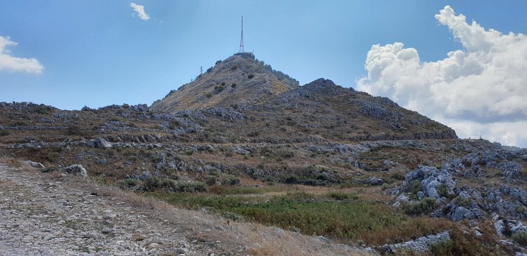
 Corfu’s highest point is M. Pandokratoras, in the Northwest of the island. Standing at 911 meters (2988 ft) it is visible from much of the island, and is distinctive for its army of masts on its summit.
The Corfu Trail (CT) visits the base of the summit before heading to its conclusion at Agios Spiridonas, a dozen miles to the North. A variant of the trail takes the hiker up the last 150m of plodding zigzags to the roof of the island.
My wife and I were staying in Kalami, on the Northwest corner of Corfu, and – naturally – I had my eye on the mountain from the first stages of planning the holiday. There are a number of routes up and I decided to follow two variants of the CT – one for the ascent and the other for the descent – which link with the coastal footpath south of Kalami, around the Kaminaki beach area.
Armed with David Brawn’s excellent map – both on paper and as a GPS-map via the ViewRanger platform – and Gillian Price’s excellent “Walking and Trekking Corfu” (Cicerone Press) – I took the rather convoluted set of paths South from Kalami, to the village of Kaminaki some three miles away. Here I climbed steeply up the road from the village to join the main road, where a left turn took me to the Shell filling station at Garnelatika. Shortly after here a lane climbs steeply upwards towards Katavolos. In theory there are some variants of the CT here – as shown on a number of maps – but they are not easily followed on the ground. At one junction there is a clear CT sign, but the route soon fizzles out. Elsewhere I did find one, but the path was overgrown with thistles and following the yellow-paint blobs was hard-going. Ideally, you need to keep to the tarmac lane until Katavolos, and then fork right, towards Rou, and climb steadily to a T-junction at around 325m.
Here I turned left and and followed the wide, rough, track upwards and Northwards, joining the CT just East of Mengoulas, at complex junction by a newly constructed building (525m). Make sure you take the higher of the two right-trending paths. From here it is a straightforward route to join the main road at the West base of the cone-shaped summit. The last 150m are hard work, but soon over.
At the summit, apart from the impressive array of telecommunications equipment, there is a cafe and the Pandokradoras Monastery – and lots of cars and sight-seers! Up until then I had not met a soul on this route.
The cafe serves a wide variety of snacks and drinks and is most welcome after the hot climb on dusty trails.
The monastery is well worth a visit, and the chapel is fascinating…
For the descent I elected to retrace my footsteps to the T-junction just North of the mountain, and then head South via Mpetrouli and Apolisi back to Kaminaki beach and hence to Kalami.
Some way down this route, at around 450m you pass the ruins of the Palies Sinies monastic community. Take the detour from the main track into the valley and feel the wonderful silence and spirit of what was once a thriving community. Two buildings – a church and an outhouse – have been renovated but the remainder of the ruins are now largely overgrown.
Once again I met not a soul since leaving the summit until Kaminaki.
This route is long and you do tire of the endless, identical, trails, especially as they wind in and out of valleys. But the peace and remoteness, especially when compared to the coastal resorts, is wonderful and to be savoured.
(22miles, 3500ft ascent)
